


Seaton Sluice is a small coastal village in the south-east corner of Northumberland, between Blyth and Whitley Bay.
A pretty walk from a harbour, up a stream then partly down the other bank. Some of the paths are narrow and irregular, so wheelchairs and buggys might struggle.
You will find three pubs and a cafe at the end of the walk, so plenty of options for that after walk drink. You pass the The Melton Constable on the left, just before the underpass under the main road. The Kings Arms is just to the right of the deep cutting at the end of the harbour, and if you cross the footbridge over to Rocky Island you will find the Watch House museum. The Waterford Arms is above the harbour, right by where we parked. Right next to the Waterford Arms is the Tower House or The Octagon. Now a private art gallery, it was originally His Majesty's Revenue Office, to collect taxes from the harbour trade.
Approximate Postcode for Satnav - NE26 4QZ.
From the A19 Tyne Tunnel road, take the Killingworth, Backworth turnoff, head for Backworth, then turn left for Seghill at the 'T' junction on the B1322. Turn right at the roundabout in Seghill for Seaton Delaval and follow this A190 right through Seaton Delaval, and down to the sea. Turn right at the roundabout at the bottom, and Seaton Sluice is about 200 yards along the coast.
From Blyth or Whitley Bay, just follow the road by the sea, South or North respectively, and you will soon get there. We parked just over the burn, on the left by the coast guard lookout, but there are other options nearby.
Click here to see a detailed routemap of the walk. It will open in a new tab.
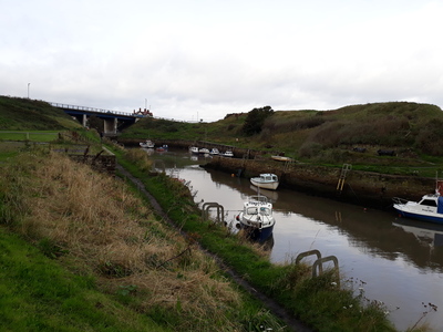
Assuming you parked on the south side of the harbour, go down steps to the water
 then head upstream towards the road.
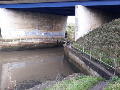
 As you reach the road, there is a footbridge that takes you over the burn, but head straight on under the main road. The path here is very narrow.
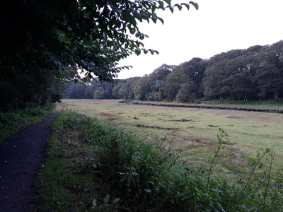
 Now the path widens and runs beside salt flats.
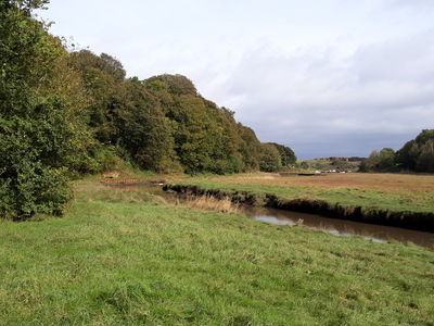
 Past the flats, you will see a pretty house over the water,
 then the path continues under a large pipe.

A short way further up you will find a footbridge that crosses the burn. You can shorten your walk by crossing here, otherwise continue up the right bank, until you reach a roadway.
 You can follow the burn right up to Holywell village, but we turned back here and retraced our steps to the footbridge, crossed over, and followed the left back downstream. In places the path was flooded as it had been raining heavily earlier.
 Keep going downstream,
 through a small stand of trees,
 and you will see the harbour again, with the first pub on your right.
 Once under the bridge, cross over the footbridge, and follow the path to the end of the harbour, where you will see a mermaid statue in the rocks.
 Now, climb up the steps again, and you will find 2 more pubs and a cafe above the harbour.
Seaton Sluice was originally part of Hartley village, and dates back at least to the Norman conquest. Monks from Tynemouth owned the area and made salt in the local salt pans, so its original name was Hartley Pans. The salt was carried along to Blyth for export for many years, until the 14th century, when the owners decided to use the natural harbour at the mouth of Seaton Burn instead. The name then became Hartley Haven, and it was also used to export coal from the local mines.
Trouble was, the harbour used to silt up, which caused problems for ships, so a certain Ralph Delaval came up with an ingenious plan to fix this. He built a pier by the sea and installed sluice gates which trapped the sea water at high tide. At low tide the sluice was opened, and the resulting rush of water scoured the sand from the harbour out to sea. The village then came to be called Seaton Sluice.
If you look at the end of the harbour today by the mermaid, you will see that a deep channel has been cut through the rocks and out to sea. This was created in 1763 and was known as The Cut. It provided another entrance to the harbour, albeit narrow and quite hard to navigate (no diesel engines in those days!). This created an island between The Cut and the original entrance, called 'Rocky Island', which can still be reached today by a footbridge.
The cut also had sluice gates so the water could be trapped at high tide, and so the ships could be unloaded and loaded at any time of the day.
Another of the Delaval clan developed a bottleworks around 1760 and they brought skilled glass workers from Germany to train up the locals. The bottles were sent down to the harbour in narrow gauge railway tunnels, some of which apparently still exist today but are not open to the public. Once at the harbour, the bottles were loaded onto 'bottle sloops' and shipped down to London, a round trip that took about a month.
'The Royal Hartley Bottleworks' was the biggest bottleworks in the UK at that time. The works had their own a market place, shops, pubs and a chapel. They also contained a brickyard, a brewery, a granary, and a quarry.
Coal was also transported from local colleries, and shipped from Seaton Sluice in 'collier boats' down to London. All this activity meant that the little harbour was a hive of industry, supporting hundreds of local workers, and almost as important as its big neighbours Blyth and North Shields.
So how did such an important port end up the sleepy little resort that it is now? The salt trade was destroyed by the salt tax in around 1800. The bottleworks closed over a hundred years ago, uncompetitive in the face of more efficient works elsewhere. The coal trade suffered a tragic end. The most important local source of coal was the Hester Pit in the village of New Hartley, but it only had a single pit shaft. The pumping engine beam snapped and fell down the mineshaft, trapping 204 men and boys underground. The Hester pit never re-opened, but after the disaster, all collieries had to have at least 2 shafts.
When parked by the Waterford Arms, I noticed a sign outside, which read:
'Susanna, Marchioness of Waterford and grand-daughter of Lord Delaval by his first marriage, inherited the bottle manufactory, the Copperas Works and the pub site in 1822 on the death of her mother, the scandalous Hussey Delaval, Countess Tyrconnel. The pub was built in 1899 to replace an earlier building and named in commemoration of Susanna.'
I was intruiged by the reference to the 'scandalous Hussey Delaval', so I looked her up. Sarah was the daughter of John, Lord Delaval, was beautiful and rich, and also strong-willed and a bit wild. Aged just 16, she married George Carpenter, the 29 year old 2nd Earl Tyrconnel who was a friend of her father.
However she soon got bored with her older husband and started looking elsewhere. She eventually became the mistress of Frederick, Duke of York, the second son of George III. Just like today, the newspapers made hay with the story of a royal affair, and Sarah became a celebrity. Despite all the publicity, her husband and father were not worried, in fact they were pleased to be associated with royalty. Frederick broke off the affair after a year, and lover, husband and father were all upset.
However Sarah did not stay unhappy for long, she soon started an affair with John, Earl of Strathmore. This love affair was also depicted in satirical prints by the press. After a while Sarah left her husband and went to live with Lord Strathmore at his house at Gibside, near Rowlands Gill. She loved riding with John around the Gibside estate, and there is a story that when riding 'her hair floated on the saddle'. Sadly, Sarah died of consumption aged 37 and is buried in Westminster Abbey.
Apparently, after she died, Strathmore had an affair with Sarah’s nineteen year-old daughter, the Susanna that inherited the Seaton Sluice works.
 Pub nearby
 poo bins available
 Cafe nearby
 Toilets available
 Historical buildings near the walk
Tap or Click on the Icon to see a picture of each walk. Click below the picture to visit the walk page.
Comments
No comments for this page yet.
Be the first to add a comment - tap the button above