Chollerford is about 4 miles north of Hexham, close to the Roman Wall.
2 short, easy walks by the North Tyne from either side of Chollerford bridge. There are two pubs on the other side of the bridge, and a shop in Humshaugh village nearby.
Postcode for Satnav - NE46 4EW - This is the post code for the George Hotel, right by the bridge.
Heading west, turn right off the A69 just past the Hexham interchange, signposted Rothbury, Bellingham, Chollerford, Acomb. Heading east, turn off just before the Hexham interchange. Follow the A6079 through Acomb and Wall villages for about 3 miles, then turn left at a 'T' junction, which takes you downhill to Chollerford bridge. The bridge is single file with traffic lights. Go straight on at the roundabout on the other side, and you will see two laybys on the left, about 100 yards uphill.
Click here to see a routemap of the walk. It will open in a new tab.
There is no pavement on this road, so walk down the grass verge back to the bridge, cross over the road, and take the footpath over the bridge, where you will see small gates on either side of the road. The left side gate leads down to a nice walk along a river bank. The gate over the road on the right leads to the ruin of a Roman bridge, but is not exactly an attractive walk. So starting on the left, walk down to the river by the bridge.
 A pathway leads upriver, beside what was a cornfield in 2023.
 The river is mostly obscured by trees, but occasionally opens out to give you nice views of the North Tyne.
 At the end of the cornfield, the pathway runs into a grassy area,
 then turns muddy as it runs through some bushes. Might be best to turn back here.
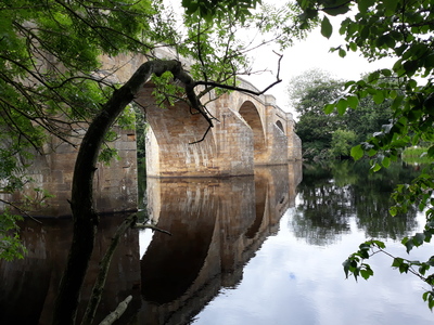
 On the way back we caught a fine reflected view of the George Hotel over the river.

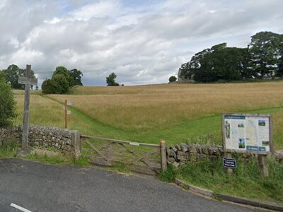
Once back to the road, it is worth trying the path on the other side, but it is less attractive to dogs. Go through the little gate, with an interesting twist on a keep shut spring, and follow the track down to a field.
 The path now runs for some distance, sandwiched between two wire fences.
 At the end of this path, you see a gateway on your right which leads down to the river.

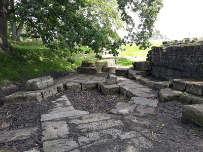
Near the river, you reach a stretch of Hadrian's Wall, with foundations of a gatehouse for the bridge at the end.
 Below the gatehouse, you will see the foundations of one of the bastions of a bridge which spanned the North Tyne. This bastion was once at the river edge, but the river has moved its course slightly west over the last 2,000 years or so.
 To the left, you will see a collection of large stone blocks, which I think were retrieved from the river. One of those blocks is shaped as a pillar.
 Now it is a case of retracing your steps back to the modern bridge again, and over to your car. The George Hotel on the left has an excellent beer garden, where you can sit with your dog, have a drink and order food.
About AD 122, the Roman Emperor Hadrian ordered that a wall be built across northern Britain to separate Roman Britain from the wild Caledonian tribes to the north. The Wall ran from Wallsend near Newcastle to Bowness-on-Solway near Carlisle. Incidentally, the wall was never the boundary between Scotland and England, not was it built 'to keep the unruly Scots out' as some claim. At the time, England and Scotland did not exist, and the Scotii were still in Northern Ireland. The wall took about 16 years to build, by 3 Roman legions totalling about 15,000 men.
The Roman wall ran about 300 yards south of Chollerford Bridge, and crossed the North Tyne just downriver. The original bridge as built by Hadrian's legions had nine arches supported by eight stone piers. About 70 years later this bridge was replaced by a new, stronger one, possibly after flood damage. The new bridge had just 4 arches and strong abutments built from huge rectangular stones bound together with iron ties, to protect the bridge from the force of the river. According to the info board onsite, the bridge had decorative stone pillars above each pier, and the stone pillar in the photo above may be the remains of one of these pillars.
Now it's not on this walk, but an important historical site lies about 2 miles away east from Chollerford bridge, straight along the B6318. As you drive along the road, you will see a small layby with a wooden cross on the left. If you take the short footpath uphill, you will come the St Oswald's Church, which marks the spot where King Oswald raised his battle standard at the battle of Heavenfield.

The kingdom of Northumbria was in a mess after AD 633, when the pagan King Penda of Mercia and Cadwallon of Gwynedd allied together to invade and kill king Edwin. The kingdom split into Bernicia and Diera again, but Cadwallon continued the assault and killed both their respective kings. According to Bede, Cadwallon ruled "not like a victorious king, but like a rapacious and bloody tyrant", killing women and children and trying to drive the Angles back over the sea.
Oswald, the brother of the dead king Eanfrith of Bernicia, was in exile in Scottish Dal Riata, but he came south to claim the Northumbrian throne, raising an army of Northumbrians and Scots. The Welsh army marched up Dere Street from York to meet him. Oswald picked a spot by the Roman wall, a narrow front facing east, with a crag on his left and the wall on his right. The night before the battle, according to the Venerable Bede, Oswald saw a vision of Saint Columba in the sky, and the saint foretold that Oswald would win the battle. Oswald then raised a cross, knelt and prayed with his men for victory.
The Welsh had the bigger army, but they were unable to make that count as the battle was fought on a narrow front between wall and crag. The Welsh line eventually broke, and the Welsh soldiers fled south with their king. Cadwallon was caught and killed at Rowley burn, just south of Hexham.
After the battle, Oswald re-united Deira with Bernicia and became king of all Northumbria. Now most of what we know about the battle comes from the Venerable One, who was biased towards all things Christian, so in his account, the battle became a triumph of Christianity over paganism. This may be true of course, but Heavenfield did re-establish Northumbria as an Anglo-Saxon kingdom.
 Pub nearby
 toilets available (in the pub)
 Historical buildings near the walk
Tap or Click on the Icon to see a picture of each walk. Click below the picture to visit the walk page.
Comments
No comments for this page yet.
Be the first to add a comment - tap the button above